
DigiPIN vs PIN Code: Key Differences & Why It Matters
Published on August 10, 2026
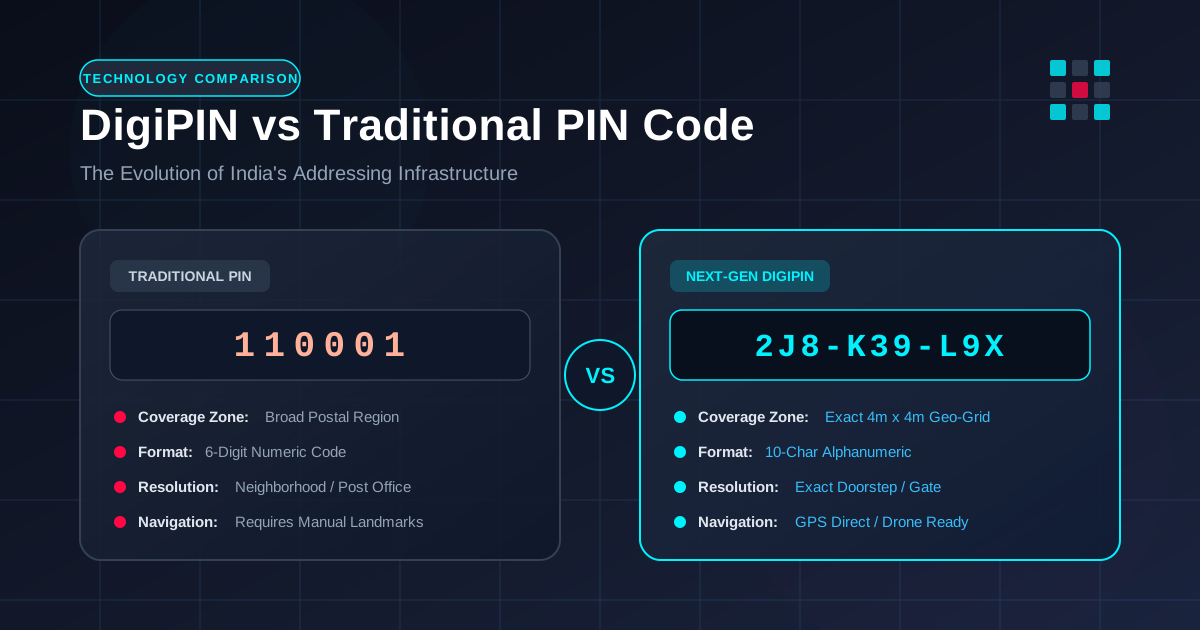
Quick Answer: While traditional PIN codes divide India into broad geographical zones covering thousands of households, DigiPIN is an advanced 10-character alphanumeric digital addressing system that divides the entire nation into precise 4x4 meter grid cells. This technological leap transforms last-mile delivery accuracy, speeds up emergency response times, and modernizes national logistics infrastructure.
For over five decades, India’s Postal Index Number (PIN) code system served as the backbone of national delivery and governance. Introduced in 1972, the 6-digit PIN code brought order to a rapidly growing nation by grouping addresses into geographical post office zones. However, in an era defined by fast-paced e-commerce, instant quick-commerce deliveries, autonomous logistics, and digital governance, traditional PIN codes are reaching their structural limits.
Enter DigiPIN (Digital Postal Index Number)—a groundbreaking initiative led by the Department of Posts in collaboration with IIT Hyderabad and geospatial experts. DigiPIN is designed not merely as an incremental upgrade to the existing 6-digit PIN code, but as a foundational spatial addressing paradigm for 21st-century India.
Whether you are a logistics professional, e-commerce operator, government planner, or everyday online shopper, understanding the structural differences between DigiPIN and traditional PIN codes is essential. In this comprehensive guide, we will explore how both systems work, compare their technical specifications, and examine why this transition matters for India’s digital future.
What is a Traditional PIN Code?
The Postal Index Number (PIN) is a 6-digit numeric code introduced on August 15, 1972, by Shriram Bhikaji Velankar, then Additional Secretary in the Union Ministry of Communications.
Structure of a 6-Digit PIN Code:
- First Digit: Indicates the geographical region or zone in India (e.g., 1 for Northern Zone, 4 for Western Zone).
- Second Digit: Indicates the sub-region or postal circle.
- Third Digit: Identifies the sorting district within that circle.
- Last Three Digits: Represent the specific delivery post office responsible for sorting and handing over physical mail.
Traditional PIN Code Breakdown (e.g., 110001)
 [1] -> Northern Zone
 [10] -> Delhi Circle
 [0] -> Sorting District
 [001] -> Connaught Place Delivery Post Office
The Limitations of Traditional PIN Codes
While revolutionary in 1972, the traditional PIN code system has major operational bottlenecks today:
- Broad Surface Coverage: A single PIN code often covers tens of thousands of homes, multiple commercial complexes, and broad rural expanses. It pinpoints a delivery office, not a specific doorstep.
- Over-reliance on Landmarks: Delivery agents must still rely on informal directions, phone calls, and landmark descriptions (“near the big banyan tree” or “opposite the water tank”).
- Unstructured Rural Addresses: Vast rural areas often lack clear street names or house numbers, leaving entire communities hard to locate accurately on digital maps.
- Human Error and Manual Sorting: Traditional mail processing requires human intervention to decipher incomplete or poorly written street addresses.
What is DigiPIN?
DigiPIN (Digital Postal Index Number) is a nation-wide, grid-based geo-coded digital address system. Instead of grouping neighborhoods into broad administrative zones, DigiPIN uses satellite data and geospatial bounding boxes to divide the entire surface of India—including its territorial waters—into uniform 4-meter by 4-meter (4m x 4m) spatial grid units.
Each 4x4 meter unit on the country’s grid is assigned a unique, non-sequential 10-character alphanumeric code.
DigiPIN Grid Architecture:
+-------------------+-------------------+
| 4m x 4m Cell      | 4m x 4m Cell      |
| Code: 2J8-K39-L9X | Code: 2J8-K39-L9Y |
+-------------------+-------------------+
| 4m x 4m Cell      | 4m x 4m Cell      |
| Code: 2J8-K39-M1A | Code: 2J8-K39-M1B |
+-------------------+-------------------+
Key Highlights of DigiPIN:
- Hyper-Precise Resolution: Pinpoints locations down to a specific doorstep, building entrance, parking bay, or agricultural plot.
- Derived Directly from Coordinates: Every DigiPIN code is mathematically linked to latitude and longitude coordinates using a open, standardized partitioning algorithm.
- Privacy-First Design: A DigiPIN string represents a spatial grid coordinate and does not store personal identifiable information (PII) such as personal names, phone numbers, or property owner details.
- Offline-Capable & Open Source: The algorithm allows applications to decode and verify grid coordinates locally without needing persistent database lookups.
DigiPIN vs PIN Code: Head-to-Head Comparison
To understand why DigiPIN represents a massive technological leap, let us analyze how the two systems compare across core operational metrics:
| Parameter | Traditional PIN Code | DigiPIN |
|---|---|---|
| Format | 6-digit numeric (e.g., 110001) |
10-character alphanumeric (e.g., 2J8-K39-L9X) |
| Spatial Precision | Large geographical zone (covers 10 to 50+ sq km) | Hyper-exact 4m x 4m grid cell (~16 sq meters) |
| Primary Basis | Administrative postal sorting regions | Geospatial coordinates (Latitude & Longitude) |
| Landmark Reliance | High (Requires house number, street name, and local landmark) | Zero (Direct pinpoint navigation to exact coordinates) |
| Coverage Area | Inhabited land mass with postal coverage | 100% of India’s territory, including oceans and remote hills |
| E-Commerce Compatibility | Low (Requires manual address parsing) | Native (API-friendly, GPS direct integration) |
| Emergency Utility | Low (Pinpoints neighborhood only) | High (Direct routing for first responders) |
Why the Difference Matters: Benefits for Key Stakeholders
The shift from zone-based postal codes to micro-grid digital addressing is not just an incremental technological feature; it is an industrial upgrade for logistics, governance, and daily digital interactions.
1. For E-Commerce, Quick-Commerce & Courier Companies
In last-mile logistics, the final 500 meters account for up to 30% of total delivery costs. Drivers waste thousands of hours combined every day placing phone calls to buyers, deciphering ambiguous street signs, and searching for unmapped entrances.
- First-Time Delivery Success: DigiPIN eliminates delivery guesswork. Courier vehicles navigate straight to the designated 4m x 4m cell.
- Automated Route Optimization: Dispatch algorithms can plot hyper-efficient multi-stop routes using coordinate math rather than text matching.
- Drones and Autonomous Fleet Support: Autonomous delivery drones and robotic couriers require exact grid coordinates to land safely—something traditional addresses cannot provide.
2. For Rural Logistics and Remote Areas
Addressing in rural India has historically been a significant bottleneck. Villages frequently share a single postal code, and house numbering is often non-existent.
DigiPIN gives every farm, rural home, primary health center, and village craft unit an official, globally unique digital address. To learn more about how this framework is revolutionizing remote address coverage, check out our guide on DigiPIN for rural deliveries.
3. For Emergency & Disaster Management
In emergency scenarios, every second counts. Calling an ambulance or fire tender with a traditional address like “Behind the Old Mill, PIN 400012” forces responders to search the general vicinity upon arrival.
With DigiPIN, dispatch teams receive an accurate 4m x 4m location coordinate. Emergency vehicles can route directly to the specific side-entrance or emergency exit, saving critical minutes during life-threatening situations.
4. For Government Governance & Urban Planning
Disaster relief distribution, agricultural subsidy delivery, property tax assessment, and utility infrastructure mapping require rock-solid spatial data. Government agencies can utilize DigiPIN as a universal spatial layer across ministries, linking land records, water connections, and electrical grids into a unified spatial database.
How DigiPIN Works: The Technology Under the Hood
DigiPIN relies on hierarchical spatial division. Here is a breakdown of how the national grid is created and indexed:
Level 0: National Bounding Box (Entire Indian Territory)
  └─ Level 1: Primary Region Regions (4x4 sub-divisions)
       └─ Level 2: District Level Grids
            └─ ...
└─ Level 10: 4m x 4m DigiPIN Target Cell- Bounding Box Definition: The algorithm sets a master bounding box spanning the extreme geographical coordinates of India (including offshore islands like Andaman & Nicobar and Lakshadweep).
- Recursive Quad-Tree Partitioning: The master box is divided into equal sub-regions, which are recursively split into smaller grids across ten hierarchical levels.
- Character Set Encoding: To make codes human-readable while avoiding visual confusion, DigiPIN uses a carefully selected 16-character alphanumeric symbol set (omitting easily confused characters like
0andO, or1andI). - Offline Decoding: Because the grid system uses mathematical spatial division, software applications can instantly translate a 10-character DigiPIN into latitude/longitude coordinates completely offline.
Will DigiPIN Replace the Traditional PIN Code?
A common question among businesses and citizens is whether traditional 6-digit PIN codes will become obsolete.
The short answer is no, they will coexist. Traditional PIN codes will remain vital for high-level sorting at national hubs and regional bulk post offices. You can think of the traditional PIN code as the macro-destination (the district sorting office) and DigiPIN as the micro-destination (the exact doorstep).
When mailing a parcel in the near future, the addressing format will seamlessly blend both:
Receiver Name: Priya Sharma
Address: Flat 402, Sunshine Apartments, Green Glen Layout
DigiPIN: 4M8-K92-P4X
City / District: Bengaluru, Karnataka
PIN Code: 560103
Logistics hubs will use the 560103 PIN code to route the package to the correct regional sorting center, while the delivery driver will scan the 4M8-K92-P4X DigiPIN to navigate directly to the building’s main delivery point.
Getting Ready for the DigiPIN Revolution
The transition to digital spatial addressing represents one of India’s most ambitious infrastructure modernization projects since the introduction of UPI for payments. For businesses and logistics leaders, preparing for DigiPIN means updating address capture forms, training routing algorithms, and integrating geo-spatial APIs.
By bridging the physical world with precise digital coordinates, DigiPIN guarantees faster logistics, reduced carbon footprints, enhanced emergency services, and true digital inclusion for every citizen across urban and rural India alike.