
DigiPIN vs PIN Code: What is the Difference and Why It Matters
Published on July 23, 2026
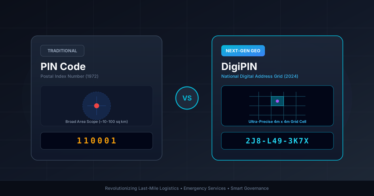
Quick Answer: While a traditional 6-digit PIN Code identifies broad postal delivery areas covering several square kilometers, DigiPIN is a modern 10-character alphanumeric geo-coded address system that pinpoints locations to an exact 4m x 4m grid across India, solving last-mile navigation challenges for courier companies, government services, and citizens.
For over five decades, finding a location in India meant relying on a 6-digit Postal Index Number (PIN Code) combined with descriptive landmarks—leading to instructions like “behind the old water tank, second blue gate on the left.” While this system powered India Post through the 20th century, the explosion of e-commerce, quick-commerce, drone deliveries, and smart governance requires far greater spatial precision.
Enter DigiPIN (Digital Postal Index Number), India’s revolutionary national digital addressing grid developed by the Department of Posts in collaboration with IIT Hyderabad.
If you are a logistics professional, e-commerce operator, urban planner, or an everyday tech-savvy citizen, understanding the fundamental differences between DigiPIN vs. PIN Code is crucial. In this guide, we break down how both systems work, how they differ, and why this shift matters for the future of Indian navigation and logistics.
What is a Traditional PIN Code?
Introduced on August 15, 1972, by Shriram Bhikaji Velankar, the Postal Index Number (PIN Code) is a 6-digit numerical code designed to streamline manual sorting and delivery of physical mail across India.
How a 6-Digit PIN Code Works:
- 1st Digit: Represents the geographical region (e.g., 1 for Northern Region, 4 for Western Region).
- 2nd Digit: Denotes the sub-region or state postal circle.
- 3rd Digit: Specifies the revenue district or sorting district.
- Last 3 Digits: Identify the specific post office responsible for physical delivery in that area.
Example: 110001
[1] Region: North | [1] Sub-region: Delhi | [0] District | [001] Connaught Place Post Office
Limitations of Traditional PIN Codes:
- Macro-Level Scope: A single PIN code covers vast geographical areas, often encompassing multiple villages, townships, or high-density urban wards spanning tens of square kilometers.
- Landmark Dependency: It routes mail to a central post office, but finding the final doorstep still relies on manual text addresses and local human knowledge.
- No Spatial Coordinates: Traditional PIN codes cannot be natively parsed by modern GPS navigation devices or automated delivery algorithms without reverse geo-coding services.
What is DigiPIN?
DigiPIN is a native, offline-capable, digital address reference framework that divides the entire territory of India—including its territorial waters—into a standardized, non-overlapping spatial grid.
Developed as an open-domain standard, DigiPIN converts latitude and longitude coordinates into a unique, human-readable 10-character alphanumeric code. Each code corresponds to an ultra-precise 4-meter by 4-meter (16 sq. m) grid cell.
Example DigiPIN: 2J8-L49-3K7X
Represents an exact 4m x 4m spatial cell containing a building entrance or delivery hub.
Key Technical Characteristics of DigiPIN:
- Precision: Pinpoints exact locations down to a 4m x 4m cell (capable of distinguishing between two adjacent house gates or apartment towers).
- Hierarchical Grid: Uses a bounding-box division system, dividing India’s geographic region recursively into smaller cells.
- Privacy by Design: Encodes geographic coordinates directly into an alphanumeric string without exposing personal names, phone numbers, or property ownership details.
- Offline Interoperability: Uses mathematical algorithms to decode coordinates into a DigiPIN (and vice versa) without needing active internet connections or central database calls.
DigiPIN vs. PIN Code: Head-to-Head Comparison
| Feature / Metric | Traditional PIN Code | DigiPIN |
|---|---|---|
| Year Introduced | 1972 | 2024 |
| Code Format | 6 Digits (Numerical) | 10 Alphanumeric Characters |
| Spatial Precision | Broad region (10–100+ sq km) | Micro-location (4m x 4m grid cell) |
| Primary Design Goal | Manual mail sorting for post offices | Digital navigation, GIS mapping, and automated logistics |
| Dependency | Requires long street addresses & landmarks | Standalone, self-contained spatial coordinate |
| GPS / API Integration | Low (Requires geocoding conversion) | Native (Direct mathematical translation to Lat/Long) |
| Offshore Coverage | Land areas with postal coverage only | Full coverage including coastal & territorial waters |
| Use Case | Traditional postal sorting | E-commerce, drone delivery, emergency services, utilities |
Why the Transition to DigiPIN Matters
The shift from a legacy regional sorting code to an exact geo-spatial grid is not merely an incremental update; it is a foundational infrastructure upgrade for India’s digital economy.
1. Eliminating Last-Mile Delivery Friction
Last-mile delivery accounts for up to 53% of total shipping costs. Delivery drivers in Indian metros frequently waste 5 to 15 minutes per order calling customers for directions, asking local shopkeepers, or navigating confusing street layouts.
By providing drivers with a 4m x 4m DigiPIN coordinate, courier vehicles and delivery agents navigate directly to the precise door or loading dock. This technology is revolutionizing modern supply chains and spatial intelligence, drastically cutting fuel consumption, delivery delays, and operational overhead.
2. Lifesaving Emergency Response
During medical emergencies, fires, or natural disasters, every second matters. Traditional addresses in rural areas or densely packed informal settlements can stall ambulances and fire services. A DigiPIN allows emergency responders to pinpoint the exact caller location, even in unmapped rural terrains or unnamed alleyways.
3. Precision Utility & Governance Mapping
Government agencies and municipal corporations can utilize DigiPIN for:
- Property tax assessments and land registry mapping.
- Tagging utility assets like electric poles, water pipelines, and telecom towers.
- Targeted delivery of social welfare benefits, disaster relief, and doorstep public services.
4. Seamless E-Commerce & Drone Logistics
As autonomous delivery drones and automated guided vehicles (AGVs) enter urban airspace and fulfillment networks, traditional descriptive addresses become obsolete. Drones require exact bounding box coordinates to land safely—a requirement perfectly served by DigiPIN’s 4m x 4m grid structure.
How DigiPIN Works Under the Hood
DigiPIN relies on a recursive spatial partitioning algorithm across India’s bounding geo-coordinates (spanning approximately Latitude 6°N to 37.5°N and Longitude 68°E to 99°E).
Level 1: Large Region (4 x 4 regional blocks)
  └── Level 2: Sub-region Division
        └── Level 3 to 9: Progressive Spatial Subdivision
└── Level 10: Final 4m x 4m Micro-Cell- Partitioning: The primary geographic region is divided into a 4x4 matrix, assigning characters from a defined 16-character set.
- Recursive Subdivision: Each square is subdivided into 16 smaller sub-squares repeatedly across 10 hierarchical levels.
- Character Encoding: To prevent human reading errors, visually similar characters (such as
0andO, or1andI) are excluded from the encoding alphabet.
Will DigiPIN Replace Traditional PIN Codes?
No, DigiPIN will co-exist alongside traditional PIN codes.
Think of traditional PIN codes and DigiPIN as serving complementary layers:
- Traditional PIN Codes act as the macro-layer, routing parcel trucks, air cargo, and bulk mail between major regional hubs and sorting facilities.
- DigiPIN acts as the micro-layer, guiding the final delivery agent, delivery drone, or visitor directly to the specific doorstep, gate, or utility meter.
E-commerce platforms will likely adopt a hybrid approach: asking for your standard PIN code for regional fulfillment center routing, while capturing your DigiPIN for seamless last-mile execution.
Frequently Asked Questions (FAQ)
Is DigiPIN mandatory for citizens?
No, DigiPIN is an open digital infrastructure designed to enhance location accuracy. Citizens and businesses can voluntarily generate and share their DigiPIN for seamless deliveries and service access.
How can I find my property’s DigiPIN?
You can search for your exact building entrance using official Department of Posts DigiPIN portal tools or integrated digital map tools, which output your 10-character code based on your GPS location.
Does DigiPIN replace my street address?
DigiPIN supplements your physical address. While your postal street address remains useful for human confirmation, adding a DigiPIN ensures digital platforms, delivery apps, and navigation devices reach your exact location without error.
Conclusion
The shift from 1972’s traditional 6-digit PIN Code to India’s modern 10-character DigiPIN marks a major step forward in spatial technology. By transforming location data from broad postal regions into precise 4m x 4m digital cells, DigiPIN bridges the gap between physical addresses and digital navigation, unlocking unprecedented efficiency for logistics, governance, and everyday commerce.