
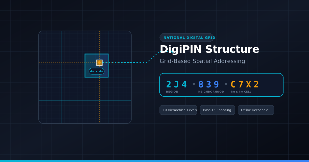
DigiPIN Code Structure Explained: Grid Addressing Guide
Published on July 25, 2026
Quick Answer: India’s DigiPIN is a 10-character alphanumeric geospatial code that partitions the nation into hierarchical 4m x 4m grid units. Developed by India Post and IIT Hyderabad, it translates exact latitude and longitude coordinates into an offline-decodable, privacy-safe digital address for hyper-accurate last-mile navigation.
From Traditional PIN Codes to Spatial Grids: The Digital Addressing Paradigm Shift
For over five decades, India relied on the 6-digit Postal Index Number (PIN) code system introduced in 1972. While revolutionary for its time, the traditional PIN code was designed for manual mail sorting across large geographic regions. A single 6-digit PIN code often covers tens of square kilometers, thousands of households, and complex rural or informal urban layouts.
In today’s digital economy—driven by e-commerce, instant quick-commerce, emergency service dispatch, and automated logistics—a regional postal code is no longer sufficient. Address ambiguity costs courier companies billions of rupees annually in failed delivery attempts, excessive fuel consumption, and phone calls asking for directions.
To solve this systemic challenge, the Department of Posts (India Post), in collaboration with IIT Hyderabad, developed DigiPIN (Digital Postal Index Number). DigiPIN transforms how locations are identified across India by shifting from text-based descriptive addresses to a mathematically precise, grid-based spatial addressing framework.
The Engineering Behind DigiPIN: What is Grid-Based Spatial Addressing?
Grid-based spatial addressing is a method of dividing physical space into standardized, non-overlapping geometric cells. Each cell is assigned a unique, algorithmic identifier derived directly from geographic coordinates (latitude and longitude).
Unlike legacy addresses that rely on landmark names, street numbers, or municipal zones, grid-based addresses are purely mathematical. They do not change when street names change, nor do they rely on subjective human directions.
+-------------------------------------------------------+
|  Level 1 Grid: Regional Zone (444 km x 444 km approx) |
|  +-------------------------------------------------+  |
|  | Level 2 Grid: Sub-Region                        |  |
|  |  +-------------------------------------------+  |  |
|  |  | ...                                       |  |  |
|  |  |  +-------------------------------------+  |  |  |
|  |  |  | Level 10 Grid: Final Cell (4m x 4m) |  |  |  |
|  |  |  +-------------------------------------+  |  |  |
|  |  +-------------------------------------------+  |  |
|  +-------------------------------------------------+  |
+-------------------------------------------------------+
Key Geographic Parameters of DigiPIN
- Bounding Box: DigiPIN covers the entire landmass and territorial waters of India, bounded approximately between latitudes 2°N to 38°N and longitudes 68°E to 98°E.
- Hierarchical Partitioning: The master bounding box is recursively subdivided into smaller sub-grids across 10 distinct hierarchical levels.
- Pinpoint Precision: At Level 10 (the 10th character of the code), the grid resolves to a physical square of 4 meters by 4 meters (16 square meters).
Anatomical Breakdown of a 10-Character DigiPIN
A complete DigiPIN consists of 10 alphanumeric characters (e.g., 2J4-839-C7X2 or 2J4839C7X2). Each character position represents a deeper level of spatial refinement within the nested grid hierarchy.
   Character Position:   1   2   3   4   5   6   7   8   9   10
                       [--- Region ---] [--- Local ---] [--- Exact ---]
   Resolution:          Coarse (Macro)    Medium (Zone)   4m x 4m (Micro)
1. Hierarchical Subdivision Mechanics
When moving from left to right along the 10-character string:
- Characters 1 to 3 (Macro Level): Broad geographic regions, state-level boundaries, or large metropolitan zones.
- Characters 4 to 6 (Meso Level): Neighborhoods, municipal wards, rural clusters, or industrial parks.
- Characters 7 to 10 (Micro Level): Specific building entrances, individual farmland plots, delivery bays, or utility poles.
Because the system is hierarchical, any two DigiPINs that share the same initial 6 characters are guaranteed to be in the exact same neighborhood. This spatial grouping enables instant sorting without complex GIS calculations.
2. The Alphanumeric Symbol Set (Base-16 Grid System)
To prevent human error and reading confusion, DigiPIN uses a specialized 16-character set derived from a $4 \times 4$ spatial matrix at each level.
The standard character set deliberately excludes visually ambiguous characters (such as 0 vs O, or 1 vs I). Instead, it utilizes a clean, high-contrast set of 16 symbols:
$$\text{DigiPIN Character Set} = {2, 3, 4, 5, 6, 7, 8, 9, C, F, J, L, M, P, R, X}$$
At every level of the hierarchy, a parent grid square is divided into a $4 \times 4$ sub-grid containing 16 smaller cells. Each of these 16 cells is assigned one symbol from the character set based on its relative row and column position inside the parent grid.
+---+---+---+---+
| 2 | 3 | 4 | 5 |  Row 1
+---+---+---+---+
| 6 | 7 | 8 | 9 |  Row 2
+---+---+---+---+
| C | F | J | L |  Row 3
+---+---+---+---+
| M | P | R | X |  Row 4
+---+---+---+---+
 Col1 Col2 Col3 Col4
How DigiPIN Calculates Coordinates: The Mathematical Logic
One of the most powerful features of DigiPIN is that it is a deterministic mathematical transform. Converting a latitude/longitude pair into a DigiPIN (or vice-versa) requires no central online database, API key, or server lookup.
1. Forward Conversion (Lat/Long to DigiPIN)
- Initialize: Define the primary bounding box of India (Latitude $[Min_{Lat}, Max_{Lat}]$, Longitude $[Min_{Lng}, Max_{Lng}]$).
- Iterate (Levels 1 to 10):
- Divide the active bounding box into a $4 \times 4$ matrix (4 equal latitude steps, 4 equal longitude steps).
- Determine which of the 16 sub-cells contains the target coordinate.
- Append the character corresponding to that sub-cell’s position to the DigiPIN string.
- Set the target sub-cell as the new active bounding box.
- Output: A complete 10-character string representing the exact $4\text{m} \times 4\text{m}$ grid cell.
2. Reverse Conversion (DigiPIN to Lat/Long)
- Read the 10 characters sequentially.
- Mathematically narrow down the national bounding box step-by-step using the row/column indices of each character.
- Calculate the center latitude and longitude of the final $4\text{m} \times 4\text{m}$ bounding box.
Because the transformation runs entirely on local CPU cycles, edge devices like delivery handhelds, smartphone apps, offline GPS units, and drone flight controllers can calculate location coordinates instantly without cellular network connectivity.
Key Benefits of DigiPIN for Enterprise and Government Use Cases
1. Privacy-Preserving by Design
Unlike standard addresses that link directly to personal identities, home owner names, or phone numbers, a DigiPIN is purely a spatial coordinate identifier. It conveys where a physical location is, not who lives there. This aligns perfectly with modern data protection regulations, including India’s Digital Personal Data Protection (DPDP) Act.
2. Unambiguous Last-Mile Navigation
Traditional postal addresses often lead delivery drivers to the back wall of a property or an adjacent alleyway. With $4\text{m} \times 4\text{m}$ precision, a DigiPIN can specify the exact entrance door, loading dock, or drop-off box of a large building complex.
To understand how this transformation streamlines enterprise supply chains, read our detailed guide on how DigiPIN revolutionizes logistics and asset mapping, where precise grid references eliminate missed deliveries and optimize fleet routing.
3. Interoperability Across Public and Private Systems
Because DigiPIN is an open national standard, it acts as a unified spatial key across diverse ecosystems:
- E-Commerce & Quick Commerce: Automated address validation at checkout.
- Emergency Response (112 / Ambulances): Rapid dispatch directly to accident sites on highways or unmapped rural roads.
- Drone Delivery Networks: Exact landing pad coordinates for autonomous aerial vehicles.
- Utilities & Infrastructure Management: Tracking streetlights, water meters, telecom towers, and transformers.
DigiPIN vs. Plus Codes vs. Traditional PIN: Technical Comparison
| Feature | Traditional PIN | Google Plus Codes | India Post DigiPIN |
|---|---|---|---|
| Primary Format | 6 Digits (e.g., 110001) |
8-10 Alphanumeric (7JWV+XX) |
10 Alphanumeric (2J4839C7X2) |
| Grid Resolution | Region/City Level ($>10 \text{ km}^2$) | $\sim 14\text{m} \times 14\text{m}$ (at 10 chars) | $4\text{m} \times 4\text{m}$ |
| National Standard | Yes (Legacy Postal) | No (Proprietary/Open Geo) | Yes (Official Gov of India Standard) |
| Offline Conversion | Requires Database | Algorithmic | Algorithmic (Base-16 Hierarchical) |
| Character Confusion Protection | Low | Medium | High (Custom 16-symbol anti-confusion set) |
| Hierarchical Search | Coarse | Moderate | High (Direct prefix spatial filtering) |
Implementing DigiPIN in Digital Workflows
Integrating DigiPIN into modern web and mobile application stacks involves simple mathematical libraries or GIS modules.
// Conceptual API for DigiPIN Encoding
import { encodeDigiPIN, decodeDigiPIN } from '@digipin/core';

// 1. Convert Lat/Long to 10-Character DigiPIN
const lat = 17.4455;
const lng = 78.3482;
const digiPinCode = encodeDigiPIN(lat, lng);
console.log(`Generated DigiPIN: ${digiPinCode}`);
// Example Output: "2J4839C7X2"

// 2. Decode DigiPIN back to Lat/Long Bounding Box
const locationData = decodeDigiPIN("2J4839C7X2");
console.log(`Center Coordinates: ${locationData.centerLat}, ${locationData.centerLng}`);
console.log(`Grid Accuracy: ${locationData.accuracyMeters} meters`);
Conclusion: The Foundation of India’s Spatial Economy
The introduction of DigiPIN marks a key milestone in India’s public digital infrastructure journey, following the success of Aadhaar, UPI, and ONDC. By organizing the physical landscape into a standardized, mathematically sound, 4-meter spatial grid, DigiPIN solves the longstanding challenges of address ambiguity.
For tech leaders, logistics providers, and government agencies, adopting DigiPIN code structures opens the door to hyper-efficient navigation, automated last-mile fulfillment, and privacy-first geospatial analytics.