
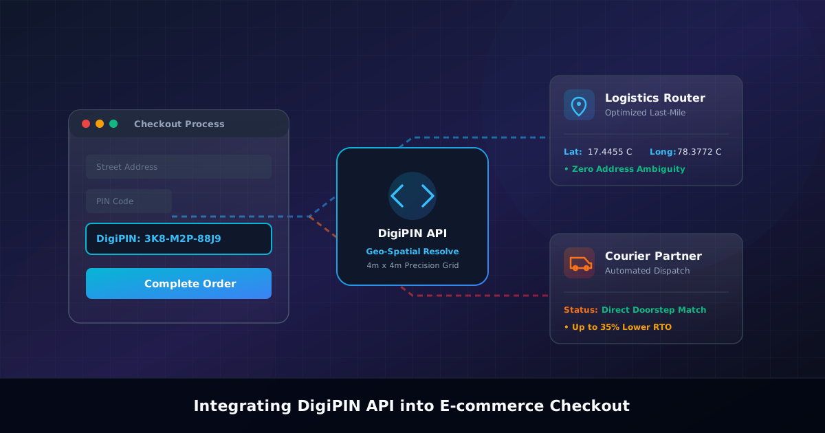
DigiPIN API Integration Guide for E-Commerce Checkout
Published on August 1, 2026
Quick Answer: Integrating the DigiPIN API into your e-commerce checkout captures a highly precise 10-character alphanumeric geo-spatial code, resolving addresses to a 4m x 4m grid. This eliminates last-mile navigation errors, lowers Return to Origin (RTO) rates, and enables automated dispatch for courier services and logistics partners.
Introduction: The Last-Mile Challenge in Indian E-Commerce
In Indian e-commerce, ambiguous street addresses, missing house numbers, and sprawling informal settlements cause severe delivery friction. Traditional 6-digit PIN codes cover vast geographical regions, often spanning multiple villages or dense urban neighborhoods. Consequently, courier drivers spend valuable time calling buyers for directions, leading to delayed deliveries, high operational overhead, and elevated Return to Origin (RTO) rates.
To address this challenge, India Post and the Department of Posts, in collaboration with IIT Hyderabad, introduced DigiPIN (Digital Postal Index Number)—a nationwide, open-domain digital addressing grid. DigiPIN partitions the entire geographical territory of India into precise 4m x 4m units, assigning each unit a unique 10-character alphanumeric code.
By integrating the DigiPIN API directly into your e-commerce platform’s checkout flow, you can transform customer address collection into a pinpoint geocoded location, unlocking seamless last-mile fulfillment for logistics fleets, courier operators, and public sector delivery services.
Why E-Commerce Platforms Should Adopt DigiPIN
Implementing DigiPIN at checkout provides measurable operational advantages across the entire fulfillment lifecycle:
- Drastic Reduction in RTO Rates: Incorrect or incomplete addresses are among the leading causes of non-delivery. A verified 4m x 4m location ensures delivery agents arrive at the exact doorstep on the first attempt.
- Automated Hub Routing: Modern courier logistics engines can ingest the DigiPIN directly to route packages to the nearest micro-fulfillment center or local delivery hub without relying on manual sorting or NLP address parsing.
- Optimized Last-Mile Navigation: Courier mobile apps can convert the DigiPIN straight into GPS coordinates (latitude and longitude) for direct turn-by-turn navigation in Google Maps or MapmyIndia.
- Enhanced Customer Experience: Buyers no longer need to type exhaustive landmarks (“Near landmark behind old water tank”). A quick 10-character code captures their precise entrance location.
Architecture Overview: DigiPIN Checkout Workflow
Integrating DigiPIN requires modifying both your client-side user experience and server-side order processing pipeline. The architecture consists of three core components:
- Frontend Address Capture: An intuitive UI widget allowing users to either manually type their 10-character DigiPIN, auto-detect their location via GPS to generate a DigiPIN, or pick their doorstep on an interactive map.
- Backend Middleware Validation: A service layer that calls the official DigiPIN resolution API to convert the code into geographical coordinates and validate regional boundary metadata.
- Fulfillment Engine Data Store: Database schemas updated to persist the primary address, standard 6-digit PIN code, 10-character DigiPIN, and extracted spatial coordinates (
latitude,longitude).
[ Customer UI Checkout ]
        │
        ├─> Option A: User enters 10-character DigiPIN
        └─> Option B: Geolocation API fetches Lat/Long ──> Encodes to DigiPIN
        │
        ▼
[ E-Commerce Backend Middleware ]
        │
        ├─> Validates DigiPIN format via Regex
        └─> Calls DigiPIN API / Local Spatial Engine
        │
        ▼
[ Order Database ] (Stores: DigiPIN, Lat/Long, Postal Code, Address Line)
        │
        ▼
[ Courier Logistics API ] (Pushes exact coordinates to delivery agent app)
Step-by-Step Technical Integration Guide
Step 1: Client-Side UI & Validation Logic
When collecting customer details during checkout, add a dedicated field for the DigiPIN. You can make this field either complementary to the standard address form or auto-populate it using client-side geolocation.
Before sending the request to your backend, validate the format on the frontend. To better understand how these 10 characters are systematically derived across hierarchical regional grids, explore our guide on DigiPIN code structure and grid-based addressing rules.
Frontend JavaScript Regex Validation
// Function to validate 10-character DigiPIN format
function isValidDigiPIN(digipin) {
  // DigiPIN uses an alphanumeric character set derived from spatial grid divisions
  const digipinRegex = /^[2-9BCDFGHJKLMNPQRSTVWXYZ]{10}$/i;
  return digipinRegex.test(digipin.trim());
}

// Example usage during form submission
document.getElementById('checkout-form').addEventListener('submit', function(e) {
  const digipinInput = document.getElementById('digipin-field').value;

  if (digipinInput && !isValidDigiPIN(digipinInput)) {
    e.preventDefault();
    alert('Please enter a valid 10-character DigiPIN code.');
  }
});
Step 2: Backend API Call (Resolving DigiPIN to Coordinates)
Once the user submits their checkout details, your application server calls the DigiPIN resolution service. This service returns the bounding box center coordinates (latitude and longitude), state, district, and nearest postal hub.
Node.js / Express Integration Example
const express = require('express');
const axios = require('axios');
const router = express.Router();

const DIGIPIN_API_ENDPOINT = 'https://api.gov.in/digipin/v1/resolve';
const API_KEY = process.env.DIGIPIN_API_KEY;

router.post('/api/checkout/process-address', async (req, res) => {
  try {
    const { streetAddress, traditionalPincode, digipin } = req.body;

    let geolocationData = null;

    if (digipin) {
      // Call official DigiPIN API service
      const apiResponse = await axios.get(`${DIGIPIN_API_ENDPOINT}?code=${digipin}`, {
        headers: { 'Authorization': `Bearer ${API_KEY}` }
      });

      if (apiResponse.data && apiResponse.data.status === 'SUCCESS') {
        geolocationData = {
          latitude: apiResponse.data.result.latitude,
          longitude: apiResponse.data.result.longitude,
          gridResolution: apiResponse.data.result.accuracy // 4m x 4m
        };
      }
    }

    // Save order payload with DigiPIN & Geo-coordinates
    const orderRecord = {
      address: streetAddress,
      pincode: traditionalPincode,
      digipin: digipin,
      coordinates: geolocationData,
      createdAt: new Date()
    };

    // Save to Database (e.g., MongoDB, PostgreSQL)
    // await Database.Orders.insert(orderRecord);

    return res.status(200).json({
      success: true,
      message: 'Address validated and geocoded successfully.',
      data: orderRecord
    });

  } catch (error) {
    console.error('DigiPIN Resolution Error:', error);
    return res.status(500).json({ success: false, message: 'Failed to process DigiPIN address.' });
  }
});

module.exports = router;
Step 3: Database Schema Design
Ensure your database architecture accounts for both legacy 6-digit postal codes and the modern 10-character spatial DigiPIN, alongside point-location coordinates for spatial queries.
PostgreSQL / PostGIS Schema Example
CREATE TABLE customer_orders (
    order_id UUID PRIMARY KEY DEFAULT gen_random_uuid(),
    customer_id VARCHAR(50) NOT NULL,
    address_line_1 TEXT NOT NULL,
    address_line_2 TEXT,
    traditional_pincode VARCHAR(6) NOT NULL,
    digipin VARCHAR(10),
    -- PostGIS geography column for spatial indexing and proximity querying
    location GEOGRAPHY(Point, 4326),
    created_at TIMESTAMP WITH TIME ZONE DEFAULT CURRENT_TIMESTAMP
);

-- Index for fast spatial distance queries
CREATE INDEX idx_customer_orders_location ON customer_orders USING GIST (location);
Edge Case Handling and Fallback Strategies
When implementing new geo-spatial systems into high-volume checkout flows, plan for legacy fallbacks and offline handling:
| Scenario | Risk Level | Mitigation Strategy |
|---|---|---|
| Legacy / Non-DigiPIN User | Low | Keep the DigiPIN field optional. If blank, rely on traditional 6-digit PIN and attempt reverse geocoding via standard street address matching. |
| Third-Party API Downtime | Medium | Implement an offline, open-source DigiPIN spatial resolution library (C++ / WebAssembly / Python) in your backend microservice to compute grid locations directly from lat/long without remote API calls. |
| Mismatched Pincode vs DigiPIN | High | Cross-check the resolved DigiPIN bounding coordinates against the polygon boundary of the supplied 6-digit postal code. Flag significant discrepancies for manual verification. |
Impact on Third-Party Logistics (3PL) & Courier Dispatch
Integrating DigiPIN into checkout fundamentally streamlines fulfillment operations for logistics companies, India Post delivery networks, and enterprise courier fleets:
- Automated Vehicle Routing Problem (VRP) Solvers: Logistics dispatch algorithms can cluster delivery destinations using spatial proximity of DigiPINs, reducing overall vehicle miles traveled (VMT) and fuel costs.
- Dynamic Micro-Hub Sorting: Packages are sorted at main distribution centers directly to local neighborhood micro-hubs using the first few characters of the DigiPIN.
- Doorstep Delivery Precision: Courier drivers open the recipient’s DigiPIN location in their mobile application, bringing them directly to the target building entrance, even in dense urban areas or unnumbered rural plots.
Conclusion
Integrating the DigiPIN API into your e-commerce checkout upgrades your infrastructure to align with India’s national digital addressing framework. By converting informal text addresses into precise 4m x 4m spatial coordinates, you reduce order fulfillment errors, optimize last-mile routing for courier partners, and lower expensive RTO rates.
Begin by upgrading your address capture forms today to capture both traditional PIN codes and modern 10-character DigiPIN identifiers, laying the foundation for seamless, automated logisitics.